| Fall 1998 | Vol. 19 |
| |
| Perhaps it is having had several recent talks with PAC Board members about this organization and with Pat Miller, Chair of the current Nominating Committee. Perhaps it's my growing awareness of what is going on in archaeology farther afield through my involvement with the SAA. Perhaps it is deciding not to run again for PAC President after my current term is up in April. Whatever it is, I find myself thinking about the future of PAC these days. What directions will this organization take? Who will be involved? What can we accomplish? I think that these are questions that we all should be asking periodically about a professional organization such as PAC. Thus, I thought I'd share some of my thoughts with you as my last President's column. There are some definite signs of health in this organization. I think
of the regular Newsletter, the symposia we've been holding each Spring,
the PHMC series of edited volumes that has developed out of this symposia,
the web presence we've created, and our many efforts in public education.
I also think of our grant writing efforts (both the successes and the failures),
the continued requests for feedback on policy and regulations from state
agencies and the small but steady addition of new members. I am enthusiastic
about what we can do with the organizational support PHMC has just agreed
to give us for our meetings, our Newsletter, and our Archaeology Month
activities and about the possibility of similar funding in the future. On the other hand, I have some worries for PAC as well. We remain a very small group, never many more than 70. Meeting attendance is low. Even the symposia and site tours such as this Fall's bus tour at Gettysburg haven't brought out a large proportion of our membership. The number of members who work on PAC's various initiatives also remains small to the point that these people tend to get burned out and discouraged about being active. Perhaps new programs, innovative workshops and symposia and other initiatives would bring more people out. Perhaps we need to be more aggressive about asking new members to take some responsibilities. However, I think that professional organizations like PAC have a tendency to have a fairly low level of participation. Those of us who are active may not like it much, but PAC isn't atypical in this respect. It seems to me that the problem may just be size. More people in the organization will necessarily mean more people able to be active in PAC initiatives. I don't mean that every new member would be active or that every member would always be active. I do think that increasing the pool of people available would be helpful. Believe me, it is an awkward thing to ask the same person to do multiple tasks over and over again. Yet the reality is that this is the way this organization has to work because there just aren't that many of us with the required combination of interest, time, and commitment. The question is obvious. Do we want to grow and if we do, how do we propose to do this? What are the obstacles to growth? What kinds of archaeologists aren't part of our membership yet might share some of our goals? How would we reach out to these people? Should we reconsider the idea of different categories of membership? Conversely, if we decide we don't want to reach out to these other groups of archaeologists, are there things we can do to increase participation and share the workload? Yet to answer this question and its corollaries we do need to know what we want PAC to accomplish. How do we envision PAC ten years from now? What can we expect to accomplish and what should we work toward being and doing? These are questions the Executive Board can discuss at our Board Meeting this Spring. I hope whoever we elect to lead this organization for the next two years will continue such discussion as well. Perhaps you would like to run for an office and be part of this discussion. If so, contact the Nominating Committee (Pat Miller, Chair, Steve Tull and Shaune Skinner). Even if you can't make such a commitment right now, won't you give the future of PAC some thought and then share with me by phone or email where you think PAC should be headed?
It has been suggested that the PAC Newsletter could provide a medium in which requests for information regarding research questions / problems could be posted. If you have such requests, please forward them to the editor (see below) for inclusion in the next Newsletter. I'm soliciting information on triangular points/bifaces from pre-Late
Woodland contexts from Pennsylvania and the Middle Atlantic Region. I summarize
existing information on existing Archaic-aged triangles in a 1998 paper
available for review at: http://www.temple.edu/anthro/stewart/ In an effort to shine some light onto the "gray" literature, the editor requests submissions for the Current Research column. These should be short descriptions of on-going or recently completed work. Reference to the full report should be included, if available. Please forward such items to the editor (see below). Many thanks to those who contributed to this issue.
Oberly Island Site Excavation (site 36NM140) The Oberly Island site is located in the Great Valley section of the Ridge and Valley Physiographic province. The site is situated on an artificial island along the north bank of the lower Lehigh River. The island was created in the 1820s when the Lehigh Canal was constructed. The site is positioned at an elevation of 60 m above mean sea level. Soils in the area are described as alluvial land with coal overwash. The latter comprises up to 50-120 cm of deposition across the island. Below the coal sands lies a historic plowzone horizon, which in turn is underlain by Holocene alluvial strata. John Milner Associates (JMA) conducted a Phase III data recovery excavation at the Oberly Island site. This work was performed on behalf of the Pennsylvania Department of Transportation and URS Greiner Woodward Clyde, prior to the proposed construction of a bridge to span the Lehigh River. In total, ten months of fieldwork were carried out over two consecutive seasons during 1995 and 1996. Lab analysis and report preparation are currently in progress. The data recovery was conducted in three stages. Stage 1 consisted of 50 1 x l-m test units systematically placed across the project area. The goal of this testing was to identify areas of greater or lesser archeological productivity. Areas determined to be highly productive were targeted for subsequent additional excavations in block configurations, constituting Stages 2 and 3 of the project. In total, 221 1 x l-m units were excavated during the data recovery, each to an average depth of 1.5 m. The major component of the assemblage consists of chipped-stone artifacts, followed by prehistoric pottery, fire-cracked rocks, and groundstone artifacts. Approximately 30 features were identified and excavated. Chipped-stone artifacts were fabricated from jasper and fine-grained black chert derived from the Hardyston and Allentown Formations in the nearby area. Projectile point types identified to date include Madison, Levanna, Perkiomen, Lackawaxen, Poplar Island, Orient Fishtail, Koens-Crispin, Archaic Triangle, Palmer, and Kirk. Most of the pottery is Overpeck Incised. Several finely carved bannerstones were recovered. Three small enigmatic groundstone artifacts are shaped like crinoids, each with a shallow groove encircling the base. Possible interpretations of these objects include protuberances on stone vessels or lip labrets similar to those documented ethnographically for the Eskimo. Fragments of steatite vessels were recovered in several areas of the site. Features include roasting pits and hearths, small pits, and artifact concentrations. The most impressive features are three large pavements of densely packed fire-cracked rocks. Included in the matrix of the largest of these features were stone netsinkers and several Lackawaxen projectile points. Charcoal from this feature was dated to 2950+/-100 BP (Beta-108183; cal 1295-1000 BC [2 sigmas]). Elsewhere in the Delaware Valley these kinds of features have been interpreted to be involved with food drying or smoking (e.g., H.C. Kraft [1975] The Archaeology of the Tocks Island Area, Seton Hall University Museum, p. 50). The Oberly Island site was discontinuously occupied from the Early Archaic through Late Woodland periods. Several radiocarbon dates have been obtained from the site, ranging in antiquity from 5425 BC to AD 1265 (calibrated, two sigmas). Analysis currently in progress is addressing spatial distributions of artifacts across the site and activity variation through time. submitted by Peter E. Siegel
Piper Airport Business Park The only thing of interest that MAAR Associates, Inc. has done in Pennsylvania recently was a survey for the city of Lock Haven at their Piper Airport Business Park project. We did locate an aboriginal burial in the middle of the airport. After contacting the PHMC, which sent out letters to each of the Iroquois Nations asking for their input, we were given authorization to remove the burial in late November. No written comments were received but one "band" suggested prompt reburial in a safe location but not in a metal container and another asked that the burial be taken out but not reinterred until they had a chance to give further consul. The burial was that of a six year old child, buried in a flexed position and disturbed by a rodent burrow. The only indication of cultural affiliation was a Clemsons Island corded rim sherd in the disturbance. We are awaiting instructions as what to do with the remains. The project area contained a scatter of prehistoric material from the Archaic through Late Woodland periods. submitted by Ron Thomas [In order to encourage the very important task of developing public support of and involvement in archaeology, members are asked to submit short items describing how they, and their firms, institutions, and organizations are interacting with the general public.] PUBLIC EDUCATION AT ASC GROUP, INC. In January of 1997, ASC Group, Inc., headquartered in Columbus, Ohio, with offices in Cleveland, Indianapolis, and Pittsburgh, hired Alan Tonetti to coordinate education services for the firm. Mr. Tonetti had previously served as Archaeological Services Manager for the Ohio Historic Preservation Office where, among other duties, he worked with local governments, historic preservation groups, land owners, avocational archaeologists, and Native Americans in conservation archaeology matters. While some of ASC Group's educational activities are internal, such as coordinating workshops and training for ASC Group's associates, many activities are external and involve the public, including completing public education components associated with cultural resource management projects. ASC Group's public education services currently include presenting workshops, demonstrations, and lectures, providing student intern and job shadowing experiences, Boy Scout archaeology merit badge counseling, and offering opportunities for volunteers. Activities involving the public are focused on students and volunteers. ASC Group's internship program is directed at high school and university students, providing them with meaningful and practical experience in a research setting. Several students with career interests in archaeology have assisted in research projects which will result in scholarly publications. Internships usually last from two to nine weeks, although some students with a serious interest in archaeology have continued as volunteers. Highlighting our public education activities was a recently completed publicly-assisted excavation on a portion of an early Late Woodland village for the City of Westerville. The site was in the path of a highway project that began as a federal undertaking pursuant to the National Historic Preservation Act some ten years ago. However, the city chose to build the highway with local funds and, therefore, the excavation was not subject to federal regulation. In the three weeks that the public participated, over 600 volunteers spent over 2,500 hours assisting in all aspects of the excavation. Volunteers continue to assist with laboratory activities. A public information meeting was held before the project began to recruit volunteers, and another meeting will be held in the Spring of 1999 following completion of the technical and public archaeology reports on the project. An exhibit is also planned. Mr. Tonetti also serves as Ohio's network coordinator for the Society
for American Archaeology's Public Education Committee, responding to inquiries
from the public in Ohio about archaeology, and also serves on the Ohio
Archaeological Council's Education Committee, organizing programs and conferences
on Ohio archaeology. For further information about ASC Group's education
services, please contact Alan Tonetti at ASC Group, Inc., 4620 Indianola
Avenue, Columbus, OH 43214, telephone (614) 268-2514, fax (614) 268-7881,
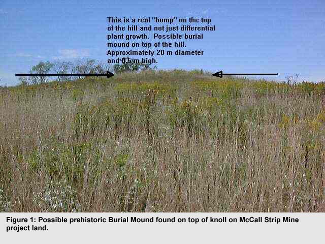
email atonetti@aol.com. COMMITTEE REPORTS Survey Priorities Committee On behalf of PAC, the Survey Priorities Committee submitted a Historic Preservation Grant proposal on June 30, 1998. The request proposed to study the existing site data within three of the 19 low-priority watersheds to identify information needs and to define environmental settings with a high probability for containing sites that would address these needs. On October 27,1998, PAC was notified that the study would not be funded. The three low-priority watersheds were to include one each from the eastern, central, and western parts of the state. A Principal Investigator, each of which was a PAC member, was to lead the study in each region, assisted by one or more Research Assistants. The end product would be a report for each watershed describing the results of the study relevant to the project goals. The team for each region would have included at least two peer reviewers, also members of PAC, who would be consulted during the course of the study and would provide comments on the final report. The study was to be performed in close coordination with the PHMC, which would have been provided opportunities to review and comment on work products during the course of the study. The reports were to be submitted to the PHMC with recommendations regarding survey priorities for upland terrain that could be generalized to adjacent watersheds. Ms. Carol Lee, Grant Manager for Historic Preservation Grants, indicated that the primary reason for rejection of the proposal was that all of the project participants were members of the Pennsylvania Archaeological Council. The review committee felt that at least the peer reviewers should have been from outside PAC and preferably from outside Pennsylvania. They believed an independent review of results would increase the validity of the study. The Survey Priorities Committee, including Pat Miller, Verna Cowin, Dan Roberts, and Phil Perazio, disagrees that anyone involved in the proposed study would be motivated by anything other than improving our understanding of prehistoric settlement patterns. Further, the committee believes that archaeologists working within the state are likely to be more familiar with the existing database. However, we will need to consider whether PAC should reapply in 1999 with a revised team structure that includes peer reviewers from outside the organization. The Survey Priorities Committee will raise this issue at the Spring 1999 business meeting. Submitted by Pat Miller This article documents a major problem that developed in response to a strip mine project in Western Pennsylvania. The Bureau for Historic Preservation (BHP) was notified by the Department of Environmental Protection (DEP) about a proposed strip mine on the McCall property in Clarion County on March 6, 1997. Unfortunately, there was no follow up on this project due to Beverly Chiarulli leaving the BHP and a lack of any recorded sites on the property. I was not given this project to check when I transferred to the BHP in November, 1997. Conversely, DEP did not send a notice to the BHP that they had approved the permit for this mine in 1997 or 1998, nor were any additional proposals received for this project (something that usually occurs as plans are revised or modified prior to permit approval) Andrew Wyatt was contacted on August 10, 1998 by a Clarion County resident who indicated prehistoric artifacts had been recovered on the property that was to be strip mined. Wyatt contacted me on August 10, 1998 about this and faxed the file about the McCall project to me on August 11, 1998. I contacted the resident who had called about the project and he reiterated that amateurs had made collections on the property. He said he had not collected on the property, but gave me the names of other people who he thought had made collections. I contacted these people, but none would state that they had actually collected artifacts on the property. However, they all said there was a site there. My general impression of these conversations was that it was very likely these people had made collections on the property, but were wary of saying so to a person who worked for a state agency. I also contacted Ken Burkett, Jr. and other SPA members from the region to see if they knew of anyone who made collections in the area of the McCall project. Burkett indicated there was a collection in the Clarion County Historical Society that consisted of a human jaw and some possible Hopewell artifacts that came from the McCall Farm. The collection was made early in this century. After learning about this, I contacted the DEP Mining office in Knox and made arrangements to meet with their permit officer, Lorraine Odenthal, who was in charge of overseeing the McCall project permit. A meeting between Odenthal and myself took place on August 20, 1998.
At that time I told her there was a problem with the McCall strip mine
project and that human burials might be present. I indicated it was likely
that the mining company would have to have to hire someone to conduct a
Phase I archaeological survey of the property. However, I had to do more
research to see if I could confirm that the collections actually came from
that specific property. Odenthal was concerned about the possibility that
human remains were present in the project area and wanted to be notified
of any additional information that I might uncover. It was also at this
meeting that Odenthal indicated a DEP memo which made it the responsibility
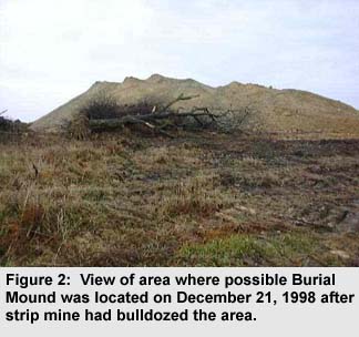
of the BHP to do any I made additional calls to Ken Burkett and other collectors in early September, 1998 to see if I could confirm information about a site or sites on the McCall property. After talking to these people, I made arrangements to visit the McCall project property on September 24, 1998. I also made arrangements to visit the Clarion County Historical Society on that date to check on the collection Burkett had mentioned. My visit to the Clarion County Historical Society failed to provide any useful information about the collection Ken had mentioned. They did not have a record of it under the name Burkett had provided. The curator was not able to locate the collection at that time. Burkett, who volunteers at the Clarion County Historical Society, indicated there is a collection that he has personally examined and he would locate it for me if I really needed to see it. Fortunately, additional information I obtained indicates any collection made on the McCall farm during the early portion of this century was not from the farm where the McCall mine project was to be located. The McCall's only obtained this property within the last 30 years. It was owned by the Latchaw family or their descendants prior to this. The collection in the Clarion County Historical Society came from the original McCall farm located south of and out of the proposed mine area. The visit to the project site was more productive. The area is located on top of a bluff above the Allegheny River in the southeastern section of Clarion County. The bluff forms the western side of the project area. There is a high knoll on the top of this bluff, the highest point along this section of the bluff that overlooks the river. Below this section of the bluff along the Allegheny River and out of the project area is 36Cll, the Parkers Landing Petroglyphs. These are a mix of prehistoric Native American and historic Euroamerican rock carvings suggesting the area was sacred or important to prehistoric groups. To the north is a bluff or high terrace that overlooks a narrow entrenched valley for an unnamed tributary of the Allegheny River. To the east and south are flat fields. All of the project area was in waist-deep grass or hay when I visited the site, except for a small section that was forested on the western side. The trees were growing on an area previously disturbed by a small strip mine that had been excavated early in the century. I was accompanied by the land owner and a representative from the mining company. I walked the project area in spite of the tall grass which limited visibility. I found a noticeable feature on top of the knoll that was about 0.5 m tall and 20 m in diameter (Figure 1). It was a small mound located on the highest point of the area, suggesting it was a prehistoric burial mound. I also asked the land owner if people had collected artifacts on his land. He confirmed that they had done so, but could not point out the exact locations where they found artifacts. This information confirmed there was an unrecorded site on the property. After the field visit was made, I sent my recommendations to the BHP office in Harrisburg and a letter, dated September 28, 1998, was sent to Milestone Crushed, Inc., the mining company, and copied to Odenthal, stating that a possible burial mound was found on the property and a previously unrecorded prehistoric site was located within the project boundaries. It was recommended that a Phase I archaeological survey be conducted by the mining company prior to DEP issuing a permit for the project. On December 2, 1998 the BHP received formal notification from DEP (there had been some phone conversations about this project during October and November) that they did not believe a mound was on the property because test drill logs indicted bedrock at only two feet below the surface. They also questioned who would be responsible for any archaeological work within the project area. The BHP did not agree with DEP's comments and indicated their response was not satisfactory. The BHP then contacted DEP to arrange a meeting on December 18, 1998 with David Hess, Executive Deputy Secretary for Policy and Communications, and other DEP representatives to discuss the McCall mine project. At this meeting, Brenda Barrett, Kurt Carr, and I presented data and photographs documenting what I had found. The DEP representatives agreed that the well log data was irrelevant and the feature I found really did appear to be a prehistoric burial mound. There also was a discussion about who was responsible for doing archaeological work in the project area. Barrett indicated the BHP did not have responsibility for the work and eventually, DEP agreed in respect to this project. One of the DEP representatives contacted Odenthal to have the permit held until further investigations could be made. It was then discovered that Odenthal had already issued the mining permit because she did not believe a mound was present. She also ignored data about a previously unrecorded site to issue the permit. Odenthal indicated the mining company had already started work on the project! She was told to have work on the mine halted if they had not destroyed the mound. Later that afternoon, the BHP was notified the mound had been destroyed by the mining operation. Arrangements were made to visit the site on December 21, 1998 to check on the damage. James Herbstritt and I visited the McCall project on December 21, 1998 to evaluate damage to possible cultural remains. It was found that most facilities for the mine had already been constructed and removal of limestone that capped the coal seam had commenced. The area where the possible burial mound was located was totally destroyed (Figure 2) Also, the mine has already damaged as much of the probable prehistoric habitation site locations as it is going to damage (there still are some undisturbed areas). There is little point in halting work now. The mining company followed permit procedures, it was DEP that ignored BHP recommendations.
The McCall Mine debacle may have some benefits. Both the BHP and DEP agree that better tracking methods need to be developed for these projects and that better communication between the agencies is needed. However. there still is the unresolved issue about who is responsible for archaeological work on strip mine projects. BHP is opposed to DEP's view that strip mine projects are covered by Act 70. This is a very important issue for PAC and the BHP encourages PAC members to voice their views to DEP. submitted by Mark A. McConaughy
FORUM [Members are invited to submit comments on issues of current concern. With luck, varying points of view will be presented.] NO SUBMISSIONS FOR THIS ISSUE by Mark A. McConaughy This column will deal with some new equipment I've been using that I am finding invaluable in conducting my work. If you already have these items, then I am sure you know how invaluable they can be. If not, then I suspect you will want to obtain them for your office. The first piece of equipment is the one most of you may already have, a color flatbed scanner. Scanner prices have dropped dramatically over the last year and a good one is very affordable. A 600 dpi color flatbed scanner (that probably can produce higher resolutions in graphics mode) can be obtained for under $200 and a cheap one can run under $100! The one I have, a Hewlett-Packard ScanJet ADF 6250 Cxi, is a little more expensive since it includes the ability to scan images up to and including legal size paper, has an automatic paper feeder and also has a slide scanner attachment. The ability to scan a long document so it will not have to be totally retyped in a word processor (assuming you do not have a disk version of it) is probably one reason scanners are purchased for use by businesses. However, it is the weakest capability of the scanner. Scanners take a picture of the page(s) being scanned and convert them to word processor readable format using Optical Character Recognition (OCR) software. OCR software is usually included with the scanner, but it is also usually NOT the most recent version or the most complete version (i.e., it is a "cut down" version) of that OCR software. The primary reason for this is to get you to purchase an upgrade to a better or more complete version. The software provided with the scanner will make a fair amount of mistakes in translating the scanned page into word processing format. A scanned manuscript needs to be carefully examined for such mistakes (th's and doubled letters are often erroneously identified by the OCR software provided with my scanner). Better versions of OCR software reduce transcription errors, but no OCR software of which I am aware produces perfect copies of manuscripts. Nevertheless, a scanned document usually can be more quickly edited than having to type in an entire document from scratch. Another use of a scanner is to copy various types of line drawings or photographic prints and change them into a format that can be included in a document. Most quality scanners excel at this function. The ability to include pictures and figures in manuscripts and reports is a very useful feature for archaeologists and other professionals. Software for manipulating the scanned image usually is also included with the scanner, but it also usually is a cut-down or older version of a more expensive program. Picture manipulation software included with most scanners can be used to change image orientation, lighten or darken images, add text and make other relatively simple modifications to the scanned image. The ability to scan slides is not a usual function of most flatbed scanners. The slide scanner attachment that comes with the Hewlett-Packard ScanJet ADF 6250 Cxi is a fairly simple item that consists of a series of mirrors designed to cover and reflect light back through the slide so it can be scanned. It is not a high quality slide scanner, but it does make fair quality scans of slides. To get a high quality scans, a scanner devoted solely to slides is recommended. These are usually much more expensive than color flatbed scanners. A slide scanner is very useful if you take a lot of slide photographs to document excavations or other project work. Slides can be scanned and used in documents in the same manner as described for photographic prints. I have found the scanner a very useful tool in my work monitoring proposed strip mine projects. It is used to scan project maps sent to me for use in field visit reports. It has also been used to scan line drawings for papers given at meetings and for manuscripts submitted for publication. I did have one major problem with my scanner. It hooks into the computer via a Universal Serial Bus (USB). Once the scanner was installed, copying files to the A: drive floppy or over the LAN system would crash the system if more than one copy episode was attempted per system boot. When the crashes first occurred, I was not sure what was causing them. I thought the controller might have gone bad. However, even after the motherboard was replaced, the crashes continued. The Unisys technician and I were totally puzzled by what was causing the crashes. It was largely by accident that we finally discovered that it was a problem that occurred only while the USB port was enabled in the BIOS. Once it was turned off, the crashes stopped. However, this did not solve the problem since the scanner could not be used with the USB port disabled. There apparently is a bug in the BIOS of the Unisys computer that causes an unidentified conflict with copying files to other drives once the USB port is enabled. Our Unisys technician did not have a fix for the BIOS problem. The only solution we have been able to implement is to turn off the USB port when I am not using the scanner and enable it when I am. I do not know if this is problem with other computers or one confined to the Unisys system we are employing. The second new piece of equipment is a Fujifilm DX-9 Zoom digital camera. This camera has a resolution of 640 x 480 pixels and comes with a 2MB flash card for storing images. It also has a 3x zoom lens with macro capabilities, a serial cable and software for downloading the camera's images to a computer and software for manipulating the pictures once they have been downloaded. This camera cost about $600 in April, 1998. Prices have been dropping on digital cameras and a comparable model should be available for less than this now. The 2MB flash card holds around 30 jpeg format pictures before the images have to be downloaded or erased. I purchased an optional 8MB flash card to use with my camera and it holds 129 jpeg pictures before it has to be downloaded or erased. I have been using the digital camera to take pictures of proposed strip mine locations, artifacts found at various sites and of other things I have found of interest (it is my camera and not one purchased by the PHMC). Work-related shots are downloaded and sent directly to Harrisburg via our LAN where they can be immediately viewed by reviewers at the main BHP office. Once I have returned from the field, downloading the photographs and sending them to Harrisburg can be accomplished in an hour or two, depending on how many pictures were taken. The digital camera has been a great asset in quickly documenting project areas and localities that have a high probability of producing cultural resources. I have also used it to photograph historic structures or known archaeological sites within project boundaries (see the McCall pictures in a previous article). These pictures are not designed to be final documentation of known cultural resources. They only serve as a rapid means of documenting their existence so BHP reviewers can make appropriate comments about project impacts. Pictures taken with the digital camera are not equal to the quality of 35mm slides, but they are good enough for general documentation. The digital camera provides a means of photographing locales and having those images available for immediate use. When time is critical and an image is needed, a digital camera and picture beats 35mm shots. There are several new digital cameras on the market that might be of interest. Sony has two cameras in their Mavica line that have 10x zoom lenses and store images on 1.44MB floppy disks. These disks can be placed into a computer and read without having to first download and save the images. The 640 x 480 resolution model runs about $700 and a 1024 x 768 pixel resolution model costs about $800 as of December, 1998. Higher resolution digital cameras are also entering the market and driving down prices of lower resolution models. Kodak has a digital camera with 1536 x 1024 pixel resolution, a 3x optical, 2x digital zoom lens and an 8MB flash card that costs about $1000. Toshiba is advertising their PDR-M1 camera as having 1280 x 1024 pixel resolution, a 2x lens with macro capabilities and a 4MB flash card that costs about $600. The higher resolution cameras still are not as sharp as a 35 mm slide, but they approach the quality of good print photographs. I expect prices to drop on higher resolution digital cameras after Christmas. If anyone is curious about digital pictures and their quality, I have posted pictures taken with my camera on my web site. The url for the site is: http://members.delphi.com/MCCONAUGHY/web/index.html There currently are digital pictures of myself, my cats, an artifact, a strip mine, Bushy Run's annual reenactment and various birds. They provide a range of photographic subjects for evaluation. The last piece of equipment that I will describe is a Hewlett Packard CDWriter Plus 7200 Series CD ROM drive. Run, don't walk, to your nearest computer store and purchase one of these or a comparable system for your computer! This piece of equipment is used to write or make CDS. An external CD-Writer drive runs around $350 to $400 and an internal CD-Writer drive costs about $250 to $300 as of December, 1998. I have an external drive that is attached to the parallel port of my computer. The parallel port printer shares this port. Only one of these devices can be used at a time. A blank write once (you can erase files, but you cannot recover the lost space) CD will format in about 2 minutes, hold up to 625 MB of data, depending on the amount of erasing, and is a far more stable medium than floppy disks. The cost for a write once 625 MB CD is about $1.50 a disk! Compare that with the cost of floppies that will hold a comparable amount of data; ~434 1.44MB floppies costing approximately $86 (~$10/50 for cheap IBM formatted floppies). The cost of a 40% larger SparQ 1 GB removable cartridge is $40 and a removable 1GB Jazz cartridge is approximately $100. It is not much of a contest, CDS are far cheaper to produce than those of other media. The disks produced by the CD Writer can be read by any system with a CD Drive using standard CD format. The Hewlett Packard CD-Writer Plus 7200 Series CD ROM drive can also make disks in music CD format. An erasable and re-writable blank CD costs about $9. It takes longer to format than a write once CD, but still holds about 625 MB of data. Its primary advantage is that there is no wasted space on the disk from erased files. However, it is still cheaper to use several write once disks with a fair amount of erasures than to use one re-writable CD. I primarily use write once CDS to backup jpegs taken with the digital camera, scanned photographs or other files that take up a lot of space on my hard drive. The CD-Writer can also be used to backup your entire hard drive onto CDs. After having problems at a critical moment with tape twisting in a tape drive backup system, I heartily recommend backing up system files on a CD. I fully expect writable CD ROM drives to eventually replace floppy drives as the "temporary" storage device of choice in future computers. They should even make 100 MB ZIP or 120 MB Superstore Drives obsolete, if they have not already done so. I definitely will not purchase another computer that does not include a writable CD ROM drive. The scanner, digital camera and writable CD-ROM drive have more than returned their initial costs. I can not conceive of doing my work without them. submitted by Mark A. McConaughy
ANNOUNCEMENTS PENNSYLVANIA ARCHAEOLOGICAL COUNCIL SYMPOSIUM ON THE CONTACT PERIOD SPRING 1999 A symposium on the archaeology of the Contact period in Pennsylvania will be held at the Spring 1999 meeting of the Pennsylvania Archaeological Council, held in conjunction with the Society for Pennsylvania Archaeology meeting in Brookville, April 23, 1999. Papers are invited on recent research in Pennsylvania or surrounding states. The papers should discuss important research results that are reshaping our concepts of the Contact period, either from the study of specific sites or from the synthesis of regional data. This symposium is one of a continuing series on the archaeology of Pennsylvania. Papers from this symposium will be published as part of the PHMC's Recent Research in Pennsylvania Archaeology series. Abstracts should be sent by mail, fax, or e-mail by January 31, 1999 to:
PENNSYLVANIA HISTORICAL AND MUSEUM COMMISSION BUREAU FOR HISTORIC PRESERVATION (STATE HISTORIC PRESERVATION OFFICE) Title: Historic Preservation Specialist (Archaeology) Contact Person: SUBMIT LETTER OF INTENT AND VITA BY FEBRUARY 1, 1999
IN ARCHAEOLOGY FIRST SUMMER SESSION: MAY 17 - JUNE 29 DEPARTMENT OF ANTHROPOLOGY Explorations on Hendrick Island in the Delaware River train students in archaeological survey and site testing techniques and contribute to the study of Native American prehistory. The island is part of the Delaware Canal State Park in Pennsylvania. It is located near Center Bridge, Bucks County, Pennsylvania and Stockton, New Jersey. Hendrick Island is entirely wooded and is typically accessed via canoe. To-date, five large prehistoric sites have been identified on the island. Artifact deposits are found on the surface and through 5 feet of buried deposits dating to about 3000 BC. Sites of an earlier age are anticipated to occur on the island and will be one focus of the ongoing survey. More detailed excavations will focus on previously identified sites. The sites include the remains of seasonal hunting, gathering, and fishing camps, and possibly agricultural farmsteads or villages. Although there will be some initial classroom meetings, the majority of time is spent outdoors doing fieldwork on the island, visiting other archaeological sites and the excavations of archaeologists working in the region. The field school generally meets five days a week (with some exceptions) for approximately 6 hours a day (9:00 AM 3:00 PM, not including travel time). Travel arrangements and car pools will be arranged during initial class meetings on-campus. All necessary field equipment is provided. Participants should be in moderately good health since we will be doing work outside. Work boots or heavy duty hiking boots are recommended foot wear. Arrangements for living locally are up to each participant. Since Hendrick Island is a one hour commute from Temple University, we do not establish a formal, overnight field camp. However, the island is convenient to full-service campgrounds on Bull's Island, New Jersey (approximately 3 miles from the island), and camping at Tohickon Valley Park in Pt. Pleasant, Pennsylvania (approximately 6 miles from the island). The New Jersey campground is part of a state park; Tohickon Valley is part of the Bucks County park system. Participants register for two courses and a total of 6 credits or semester hours: Anthropology 320 (Field Session in Archaeology = 3 credits; course reference #016-337) and Anthropology 321 (Archaeological Methods = 3 credits; course reference #016-346). Graduate students should register for the equivalent courses: Anthropology 520 and 521. Undergraduate Costs = $196/credit (PA residents), $297/credit (non-residents); Graduate Costs = $287/credit (PA residents), $400/credit (non-residents). Non-matriculating students or students from other universities should contact the Department of Continuing Education (215-204-1331) for instructions on how to register. There are no pre-requisites, although some background in archaeology is helpful. Two texts are required reading and are available through the Temple University Bookstore: Hester, Thomas, Harry Shafer, and Kenneth Feder Sutton, Mark and Brooke Arkush THE FIRST MEETING OF THE CLASS WILL TAKE PLACE ON-CAMPUS, MONDAY, MAY 18. MEET IN ROOM 314 GLADFELTER HALL AT 10:30 AM. FOR MORE INFORMATION CONTACT: DR. MICHAEL STEWART, DEPARTMENT OF ANTHROPOLOGY, TEMPLE UNIVERSITY,
PHILADELPHIA, PA 19122. 215-204-6188 (Dept. office); 609-758-7838 (home
office); email: schurch@ushwy1.com Middle Atlantic Archaeological Conference Pennsylvania Archaeological Council Society for Pennsylvania Archaeology ** Please send notices of upcoming events to the editor. The expanded PAC web site is up and running. The URL is http://www.cs.pitt.edu/-bev/pac.htm Many thanks to Pat Miller for her efforts to bring this about. EDITOR'S NOTE ****************************************** |
|
|
| |